THE HOLLINGWORTH TO RAKEWOOD TOLL ROAD
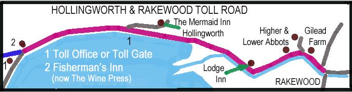
Around 1818 James Wild constructed a toll road for Messrs Midgeley and Rhodes next the weir (approx where the Wine Press is) to the bottom of Hollingworth Brow (now called Bear Hill) which superseded a foot-road. Messrs Midgeley and Rhodes paid the Canal Co £1 pa for the privilege of taking the road over the dam. The road was extended at the same time to Rakewood. Tolls were collected irregularly so having fallen into dis-repair it was taken over by the Canal Co circa 1836. John Taylor of Higher Fold collected the Tolls on behalf of the Canal Co from 1840 or 41 but collection was still irregular. Henry Blackburn from Milnrow recalled that when travelling during the period 1842 to 1847 the toll bar or chain was located at the bottom of Hollingworth Brow where two gas retorts remain. On 13th April 1892, by agreement with the Proprietors of the Rochdale Canal Co, the Littleborough UDC advised that “This road is open to the public” subject to various conditions including weight limits .
TOP
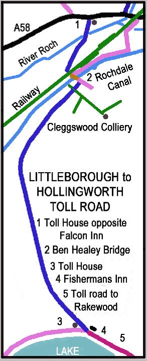
LITTLEBOROUGH to HOLLINGWORTH PRIVATE TOLL ROAD
Circa 1831 or 1832 a Mr Smith speculatively built a toll road from opposite the Falcon Inn to Hollingworth Lake including a bridge over the River Roch, then crossing the canal at Ben Healey Bridge . Toll bars were located at the Fisherman’s Inn and opposite the Falcon Inn . Later Mr Johnstone Head, constable, of Rochdale, erected two lime kilns (with separate access road) near the canal bridge, and commenced to burn stone, which was brought to the place in boats - see plan below. Whether prior knowledge enabled Messrs Smith and Johnstone to gain material compensation for their losses is now uncertain but just a few years later the surveyors for the Manchester and Leeds Railway duly arrived and preparations began for making the line”. With the coming of the railway the toll road was severed but the footpath remained as a reputed ‘Right of Way’. When the railway was built the road to Littleborough was severed but no thought appears to have been given to how traffic from Hollingworth Lake was meant to reach Littleborough or even the station itself. In the 1870s the owner of the road suggested that the Littleborough local board take over the toll road on some conditions but nothing of consequence happened. The Toll Road to Hollingworth Lake was adopted by the Littleborough Local Board in 1882 Littleborough Square was completed in 1888.
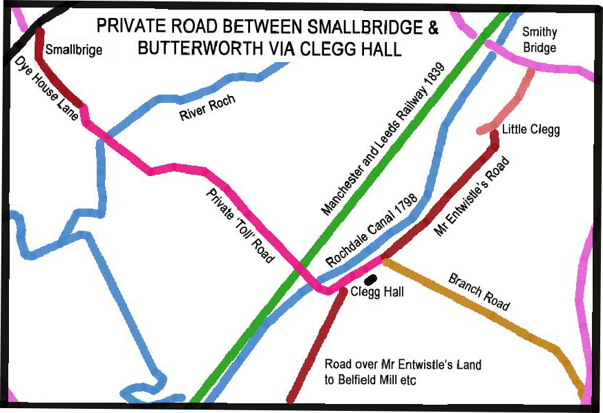
MR ENTWISTLE’S TOLL ROADS SERVING CLEGG HALL
In 1801 a Mr Entwistle built at considerable expense a private road for horses and carriages for use of his tenants only through his farms in Hundersfield and Butterworth commencing at Smallbridge and ending at the Highway at Winnian or Union Flash in the Butterworth. He issued a Public Notice “That as the said road is cut and made entirely through Private Property – ‘All Persons presuming to go or to travel the same without leave or by Agreement in Writing or paying a toll as required at the Toll Houses (Foot Passengers excepted) will be prosecuted with the utmost severity of the Law’, John Entwistle, Foxholes, Oct 13th, 1801”.
The road between Clegg Hall and Little Clegg was known locally as Mr Entwistle’s Road and originally extended beyond Bellfield Mill to Newbarn on Milnrow Road over land marked on the 1786 map as XX Entwistle Esq., presumably the same Mr Entwistle. The link to Smallbridge thus being an extension to the earlier network of private roads. The stretch of the old road from Clegg Hall to the River Beale at Bellfield Mill is still extent but is now an unused green lane. Branch Road farm (known as Branch Royd farm in a 17th Century Manorial Survey) was connected to Milnrow Road and Belfield etc by a number of minor tracks. It may well be that Branch Road (to Wildhouse Lane) may also have been built by Mr Entwistle to connect his network of roads.
TRACKS AND ROADS AROUND HOLLINGWORTH LAKE
In addition to the Hollingworth and Rakewood Toll Road, the Rochdale Canal had a number of gates situated around Hollingworth Lake which were locked for a day each year. In April 1953, H Percival recalls some 6 gates located:
1. near the Beach Hotel; . 2. opposite the landing stage; 3. corner of road to Littleborough;
4. near road to Higher Cleggswood; 5. next to Bear Hill House;
6. Bridge at top end of lake – closed Sept 1939 but re-opened 1940.
Gates 1, 4, 5 & 6 were still extant when his note was made.
The Rochdale Canal Co also erected a brass plaque ‘in the road’ between Yell Lane and the first house (built on the site of the old L&Y Hotel) “RGC – NO RIGHT OF WAY- NORTH WEST OF BOUNDARY STONES – FIXED IN LINE 41 YDS – SOUTH WEST OF THIS POINT”
Next page TOP
.
OTHER TOLL ROADS AROUND HOLLINGWORTH, THE LAKE AND LITTLEBOROUGH