
ll

Blackstone Edge
Blackstone Edge rises fairly rapidly to tower over Littleborough with the current main road rising from 474 ft (157 metres) next to Littleborough’s Viaduct to a maximum of 1,275 Ft (389 m) at its summit next to Blackstone Edge Reservoir. One of 5 built for the Rochdale Canal Co at the turn of the 18th Century and improved in the late 1920s by Rochdale and Oldham Councils.
The current or new road joins that part of the old or ‘Coach Road’ still open to normal traffic at the Bar House standing at 824 feet (251 m) or 350 ft (107 m) above the Town Centre.
From the Bar House, Horse Drawn Coaches had to climb a further 414 ft (126 m) to reach the White House where the horses were changed or rested and the passengers enjoyed warmth and refreshments (and still do!). The new road was adopted by the Royal Mail in the 1825. It is known that Ann Lister from Halifax went to meet a friend at the White House in the early 1820s and therefore the coach would have travelled from near Halifax and Ripponden via Turnpike Roads.
Trig Point at 1553 feet installed by the intrepid military
Restoring the Aiggin stone during 20th Century
Turvin Road closed and Blackstone Edge Reservoir to the left both snow-covered
19th Century Bunfire ready on Blackstone Edge (below)
In the 19th and 20th Centuries Blackstone Edge was the location of numerous political and religious meetings drawing huge crowds and Bunfires lit there to celebrate coronations etc.
Today, the roads are probably busier than ever with the Pennine Way and shorter walks (see Booklet below) attracting numerous visitors from UK and abroad, pitting their enjoyment against whatever the weather may decide.
But when weather is clear the view to North Wales and the Cheshire plain is a delight and the night-time view is possibly unmatched in the area
Why not get hold of these to Booklets - from Kelsall’s bookshop in Littleborough Square or the White house of contact the History Centre via lborohist2@gmail.com
See also History Trails for more local walks
For Hare Hill Park see here
Littleborough and Blackstone Edge are noted for the listed, so called ‘Roman Road’. Whether it is Roman or the first Turnpike Road, the roadway climbs for some 750 feet (231 m) from Rough and High Peak to the road’s summit just beyond the ‘Aiggin Stone’ a way-marker or sone with incised cross. Both ‘Roman’ Road and the main road fall some 800 feet of more to Ripponden. The so called ‘Roman Road; is pictured left looking down to Blackstone Edge (New) Road
Visitors. Travellers, residents and Quarrymen
From stone age, through the Roman era to the English Civil War, mankind has crossed over, lived on and worked the resources of Blackstone Edge wether animal or mineral and at times an unforgiving landscape with often cold and wet weather generating treacherous bogs. But as Littleborough developed so too did the need for building materials including steam engine beds (large and heavy stone blocks). Even now the many quarries are visible scars on the landscape better seen when snow covers the ground (right)
Quarrying gradually ceased in the mid-19th Century when the tax on bricks ended and brickworks sprung up in Summit and Rock Nook next to the Todmorden to Littleborough Turnpike and the Rake Brickworks adjacent to the Coaching Inn of the same name.


| History Centre |
| Contact Us |
| Gordon Harvey |
| Town House Mill |
| Richard Jay - Coach Operator |
| William Burrill |
| Richard Jay Haukier |
| Leach - Cycles to Haulage |
| H M Sutcliffe |
| J Grindrod & Son Ltd |
| R Rudge and Son Ltd |
| Canal Restoration |
| Industrial Histories |
| History Trails |
| Littleborough Book |
| Littleborough Books |
| Pubs & Inns |
| Early Schools |
| Non-conformist schools |
| C of E and RC Schools |
| Board and Local Authority Schools |
| Chapels iSummit & Calderboork |
| Closed Chapels Shore Caldermoor Croft |
| Chapels Featherstall Stubley Rakewood |
| Rechabites |
| Clegg Hall & Smithy Bridge |
| Smithy brige Train Distaster |
| Railways in Littleborough Centre |
| Littleborough Viaduct to Summit Tunnel |
| Summit Tunnel |
| Industrial Railways |
| Was summit Tunnel Necessary |
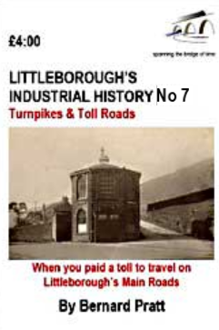
| Blackstone Edge Turnpike |
| Calderbrook Turnpike |
| Doghill to Steanor Bottom Turnpike |
| Todmorden Rd TP |
| Toll Roads |
| Farming |
| List of Farms |
| Co-op - Early Grpwth |
| Coop - Central Premises & Competition |
| Coop in 20th Century |
| Coop Decline & Change |
| LANCTAN |
| Schofield Iron Woks |
| Phoenix Iron Works |
| Ebor Engineering |
| Deanhead Chemical Works |
| Akzo Chemical Works |
| Law's mills |
| Clegg's Shore Mills |
| Consterdine textile Mills |
| Schofield Textile Mills |
| Heap's West View Mills |
| Rayon (Artificial Silk) Manufacture |
| Mills |
| Starring Pottery |
| Summit Brickworks |
| Tetlows Pottery |
| Whittaker Pottery |
| Coal Mining Map |
| Starring Clay and Coal Mine |
| Cleggswood Colliery |
| Shackleton - Coal Merchant |
| Mining around Hollingworth |
| Possible Roman Littleborough |
| Blackstone Edge Roman Road |
| Falllen Heroes not on Littleborough Cenotaph |
| Roll of Honour |
| WW2 Heroes |